


*Le Perray en Yvelines

jpcccb
User
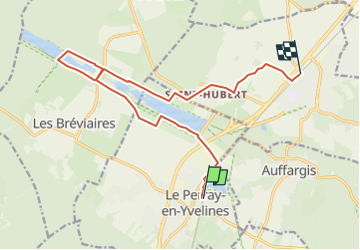

Length
14.4 km

Max alt
188 m

Uphill gradient
99 m
Km-Effort
15.7 km

Min alt
171 m

Downhill gradient
100 m
Boucle
No
Creation date :
2020-03-09 12:52:40.575
Updated on :
2024-04-27 09:50:01.748
3h34
Difficulty : Easy

FREE GPS app for hiking
 SityTrail
IGN / Geographical institutes
SityTrail Plus
The world is yours!
About
Trail On foot of 14.4 km to be discovered at Ile-de-France, Yvelines, Le Perray-en-Yvelines. This trail is proposed by jpcccb.
Positioning
Country:
France
Region :
Ile-de-France
Department/Province :
Yvelines
Municipality :
Le Perray-en-Yvelines
Location:
Unknown
Start:(Dec)
Start:(UTM)
415873 ; 5393998 (31U) N.
Comments